-
In the era of big data, researchers now have access to worldwide datasets from NASA and other research entities. Many datasets have been made accessible from Google Earth Engine (GEE), but the native tools for working with GEE require workflows that are less reproducible, less familiar to most natural resources programmers, and not easily integrated into larger programming projects. This course will focus on bringing GEE datasets into a Python workflow to more easily integrate the data acquisition process into geospatial analysis projects in a reproducible manner, on any operating system, using open-source software. This course will model how to set up a geospatial analysis project workflow that can serve as a template for future projects. We will learn common geospatial data types and programming control flow techniques, how to download and save geospatial data from GEE, how to convert between formats, and how to use Python modules to enhance or speed up geospatial analysis techniques commonly employed manually in other software packages.
-
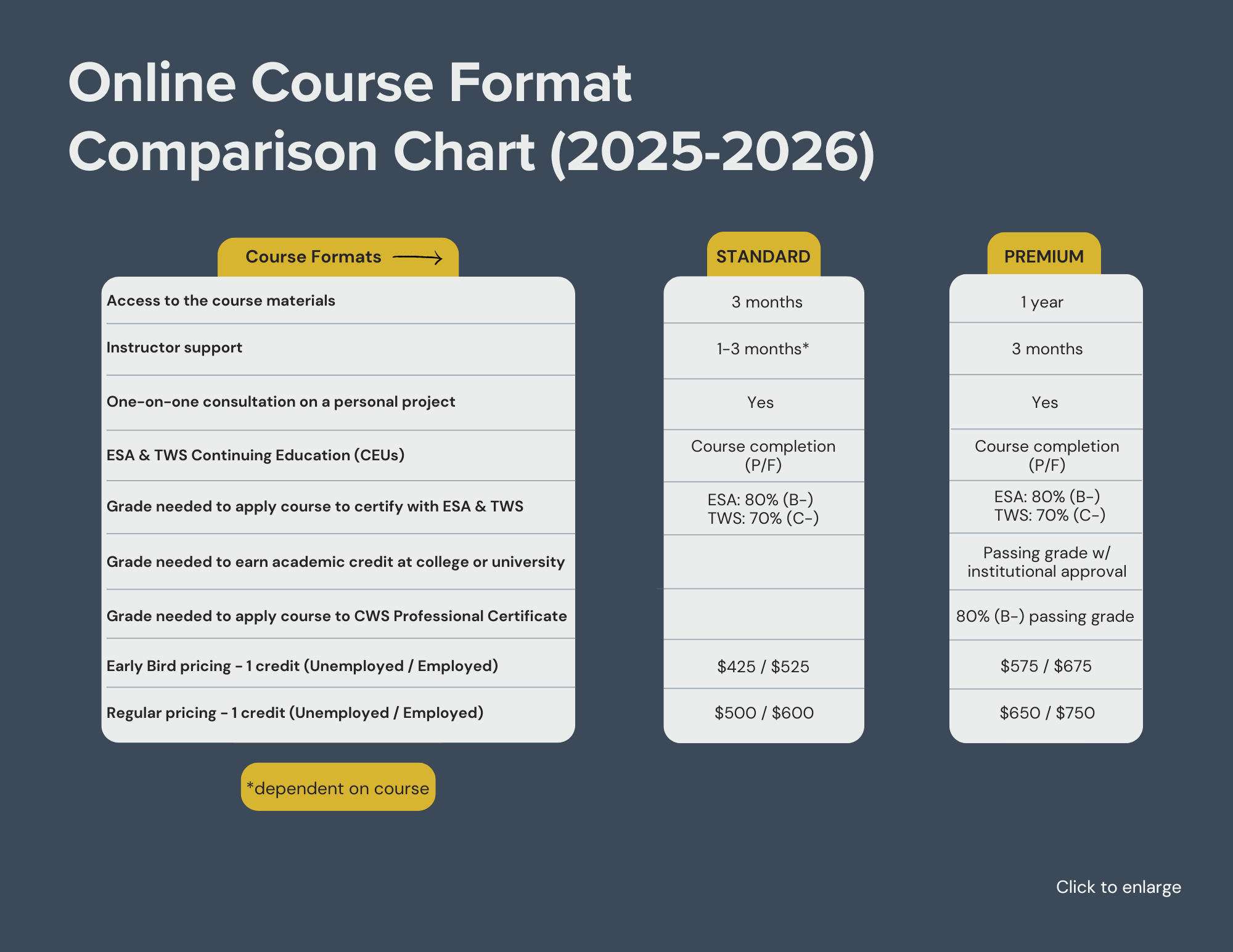
Learn at your own pace with instructor support (see Online Course Format Chart below for details).
Fall: October 14, 2025 – January 5, 2026 (Early bird ends September 14th)
*Early bird saves $75
-
Basic experience with GIS; basic experience in Python (e.g., from CWS’ Python Boot Camp); and a Google Earth Engine account.
-
Module 1: Getting Started with Python and GEE
Create and manage a Python environment
Create, edit, and manage Jupyter Lab notebooks
Distinguish between and create data structures available in Python
Construct control flow operations in Python
Import and access functions in Python modules
Distinguish between GEE data structures
Load datasets from the GEE catalog
Module 2: Viewing, Manipulating, and Exporting GEE data
Perform server-side filtering, summarization, and joining operations
Download GEE data structures as files
Create static and interactive maps using GEE data structures
Module 3: Arithmetic and Comparison Operations
Perform calculations on Images using arithmetic operations
Detect changes between Images using comparison operations
Remap Image values to reclassify data
Module 4: Advanced Image Analysis
Perform classification of Images using the ee.Classifier and ee.Clusterer submodules.
Calculate aspect, hillshade, slope, and related metrics using elevation data.
Perform classification of aerial imagery using the geoAI module.
Perform complex raster and vector analysis techniques using the whitebox module.
COURSE OPTIONS & INFORMATION (Review chart above, then click below)
-
FORMAT:
3 months of access to course materials as you work at your own pace
Get instructor support for the 3-month term via email, discussion threads, group meetings, and one-on-one appointments
After working through the course materials, set up an optional meeting with the instructor to discuss your own personal project from work or school
CONTINUING EDUCATION:
16 CEUs with The Wildlife Society
CERTIFICATIONS:
Earn 1 credit toward certification as an Associate/Certified Wildlife Biologist® (at any level) with The Wildlife Society
-
FORMAT:
12 months of access to course materials as you work at your own pace
Get instructor support for the 3-month term via email, discussion threads, group meetings, and one-on-one appointments
After working through the course materials, set up an optional meeting with the instructor to discuss your own personal project from work or school
CONTINUING EDUCATION:
16 CEUs with The Wildlife Society
Go to our Continuing Education Page for more details
CERTIFICATIONS:
Earn 1 credit toward certification as an Associate/Certified Wildlife Biologist® (at any level) with The Wildlife Society
ACADEMIC CREDIT:
Earn 1 academic credit (go to our Academic Credit Page for details)
Earn an additional 1-2 academic credits with an Applied Project
INSTRUCTOR
SCHOLARSHIPS
Full scholarships are available to participants from countries designated as “lower income” and “lower middle income” in the World Bank List of Economies. Please see our CWS World Scholars Program page for details.
CANCELLATION POLICY
Cancellations 30 days or more before the start date are not subject to cancellation fees. Cancellations <30 days before the start date are subject to a 50% cancellation fee. No refunds once the course begins.


